
FRAMEWORK I: DISTRIBUTION
Early-December snow and avalanche update, the importance of reporting near-misses, and the laying of the foundation.

We will start with a look at weather and avalanches and then dig a little deeper into some theory. With these writings, I am attempting to offer you a different way of understanding the snowy world around you. In order to build this framework we first need to smooth the ground and lay a foundation. We are getting into the meat of this now. The ideas presented in these Framework sections will be referred to over and over again here and will build off of each other. But first, let’s dive into some weather and avalanche conditions.
WEATHER AND CONDITIONS
Pre-Thanksgiving storms brought significant amounts of water and snow to the Intermountain West, favoring the Sierra, Utah, and Colorado (map of snowfall distribution below).
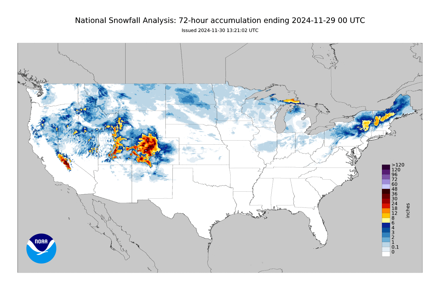
The snow came in warm and dense, with favored locations tallying 1-2.5 feet of snow and up to 4 inches of SWE! This snow fell on a variety of weak snow surfaces that developed during the extended mid-November drought. The equation here is simple: rapid loading + widespread weak snow surfaces = avalanches!
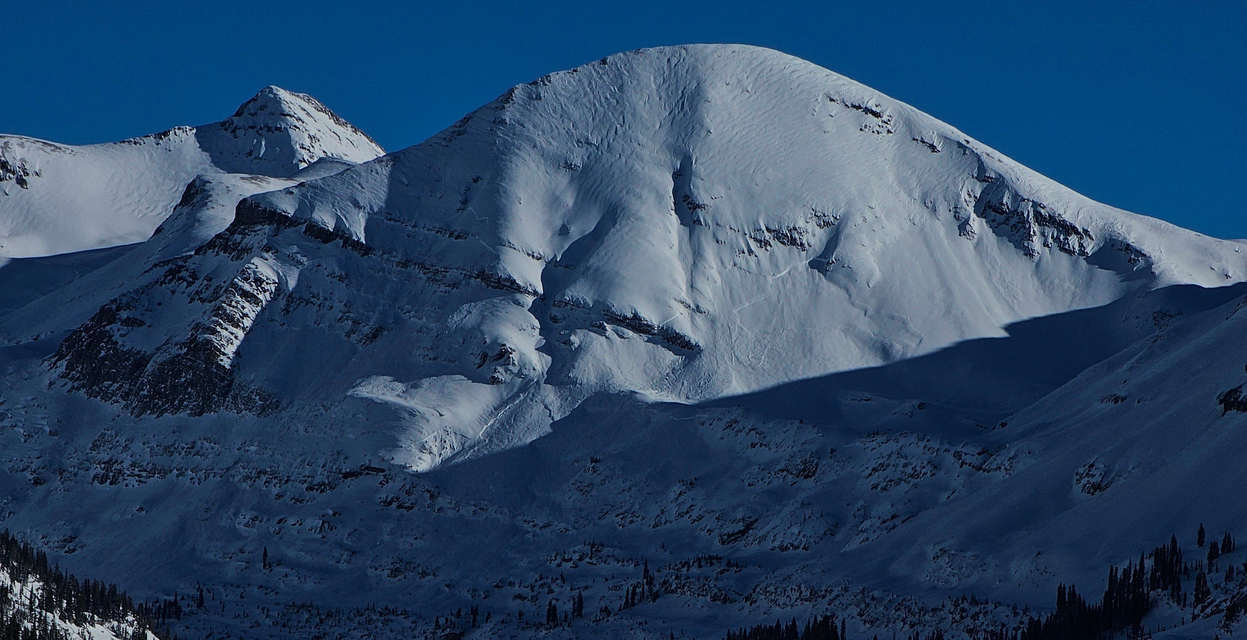
A number of large avalanches were triggered in Utah and Colorado this week. Colorado also hosted an impressive natural avalanche cycle that seemed to be most intense around the area of Crested Butte. Slides here broke up to 1,000 feet wide and wrapped around aspects and terrain features. Avalanche activity was focused on shaded slopes (northern half of the compass) at middle and upper elevations, where lingering snow from earlier in the fall was most widespread. This is a very typical pattern for early-season persistent slab problems.
As is often the case, snowfall in the Continental US generally makes for dry conditions for our neighbors in Alaska. Following a 2 week drought, precipitation is returning to coastal Alaska today. Snowfall is relatively light to begin with, but this area is expected to pick up feet of snow accompanied by strong winds over the coming week. If you’re following along closely, the recipe is becoming familiar: long droughts build persistent weak layers and major loading events overload these weak layers producing avalanche cycles.
The indomitable Wendy Wagner from the Chugach Avalanche Center does a good job showing what this snow looks like in the Turnagain Pass area in the video below:
RECENT AVALANCHES
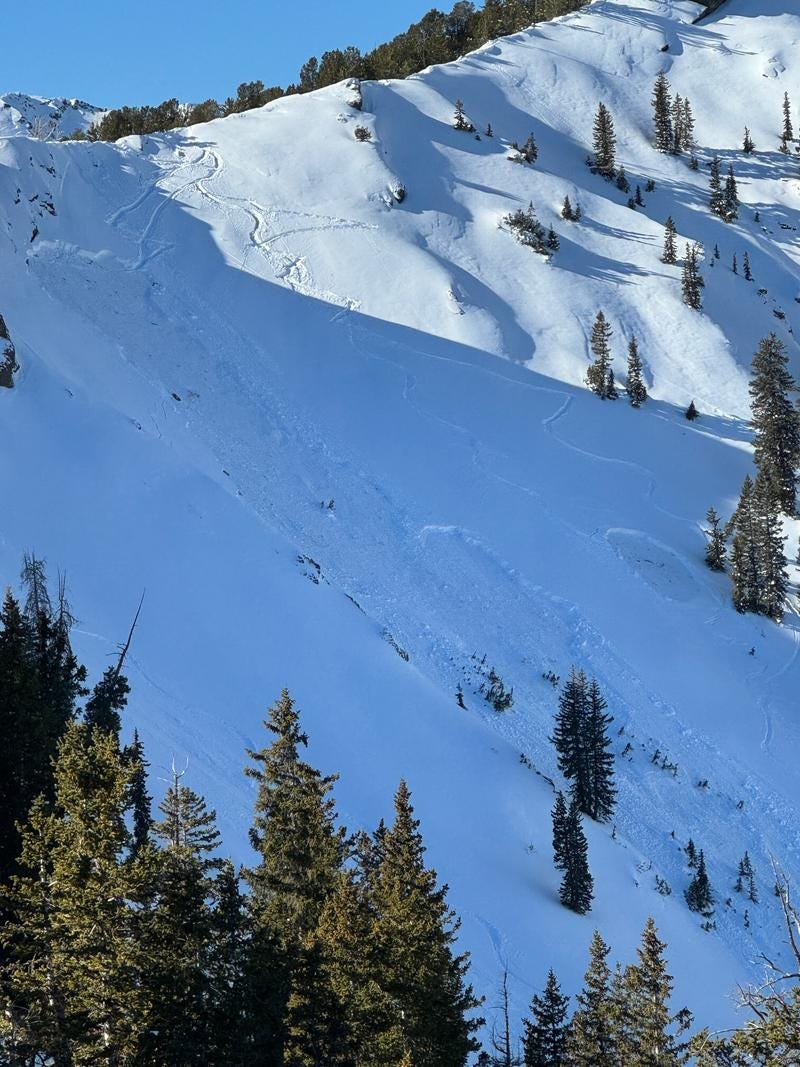
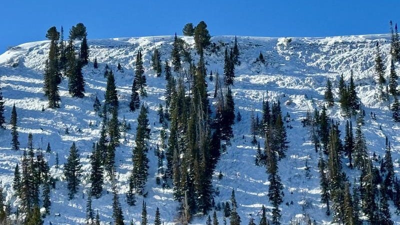
The slide pictured above, in the Days Fork of Big Cottonwood Canyon, UT, was remotely triggered by skiers and reported to Forecasters at the Utah Avalanche Center on Thursday, 11/28. This is a good first-hand account of a near-miss, take the time to read the observation. As always with accidents and near-misses, your job when reading these reports is to see how you might have ended up in the same situation, not to tell yourself that you wouldn’t have made the same mistakes. Kudos to the reporting party for taking the time to write this up and submit it. Reflecting on near-misses is how we learn from them.
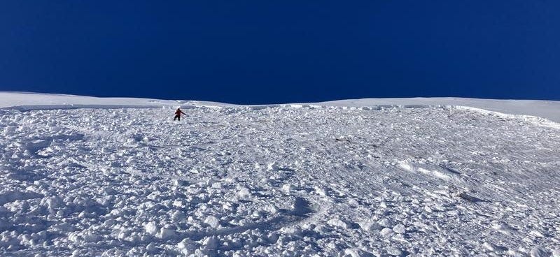
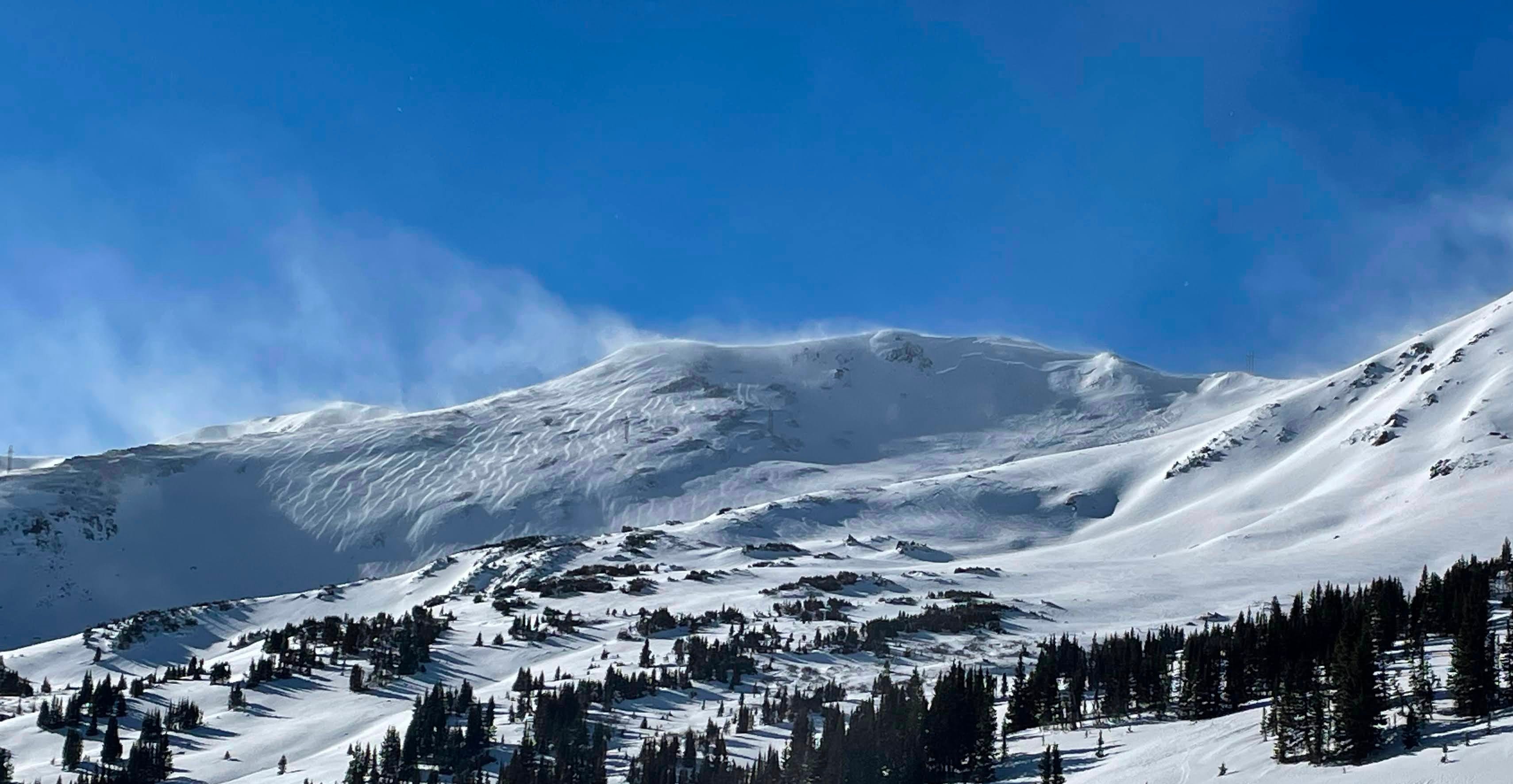
The shallow but wide persistent slab avalanche pictured above was triggered by a snowboarder on West Monitor Bowl, on the Park City Ridgeline. The rider was able to turn and ride off the slab and was not carried or buried in the avalanche. On November 29, Forecasters with the UAC went to investigate these slides and ran into a party who had just triggered a third avalanche in same general area. You can find the observation from the UAC Forecasters here. There is some good information in there, including a look at the similarities and differences between the slabs and weak layers involved in these avalanches.
It is refreshing to see these parties reporting their near-misses. It is far too easy to ignore these incidents and to pretend they didn’t happen. This is a trick our brain plays on us to protect our egos. But I am not worried about your ego, I am worried about you. Making mistakes is human, you will make them throughout your life. Deciding not to learn from them sets you up to make the same mistakes over and over again.
LOOKING AHEAD
A broad ridge of high pressure is keeping moisture away from the continental US and allowing for warming temperatures this week. You may be experiencing conditions more reminiscent of spring than early December if you head into the mountains. Bring your sunscreen, be on the lookout for natural and human-triggered wet snow problems, and don’t forget that the weak layers responsible for this week’s avalanche activity have not gone away.
This weather pattern should last through much of the week. Precipitation returns to the Pacific NW late on Friday as a cold front sweeps across the region, bringing rain and snow to the Cascades, Northern and Central Idaho, and Western Montana over the weekend. Temperatures will be warm to begin with, bringing rain to lower elevations and heavy snow above. Temperatures cool, snow density decreases, and lighter powder falls on Sunday. Snowfall shifts south to Wyoming, Utah, Colorado, and New Mexico over the first few days of next week.
We are adding another weak layer to the mix during the current stint of high pressure. Facets on shaded slopes, thin crusts with associated crusts on solar margins (E-SE, WSW-W), and thick crusts with or without crusts on solar slopes. When complexity increases, the task of finding the overlap between high-quality snow and stable riding conditions becomes more difficult.
DISTRIBUTION: WHAT IS WHERE and WHY DO YOU CARE?
OK, now for a little theory. We are setting the ground rules for how we look at, understand, and move through the world of the snow. These ideas are simple but important.
The concept of distribution is fundamental to backcountry travel. Defined simply, distribution describes the presence of a given quantity in space. Here are a few metrics whose distribution might be important to you: new snow, old snow, wind-affected snow, stable snow, unstable snow, slabs, weak layers, slope angle, slope aspect, etc., etc. On any given day in the backcountry, you are searching for the overlap of some of these while avoiding others. Generally, the question you are probably asking is, “Where can I find good, stable snow?”
In the early season, as the snowpack develops, our focus on distribution is aimed at the presence of early-season snow. These layers of early-season snow that linger can make for ugly persistent weak layers. Is some of this sounding familiar..? If you read the first half of this post it should be! We can increase our safety margins by mapping the presence of older, weaker snow prior to loading events and giving this terrain a wide berth.
As the snowpack develops over time, complexity increases and we find ourselves mapping the distribution of many things simultaneously. Among other metrics, we may need to know:
where weak snow makes up the base of the snowpack
where the wind is putting the snow during storm events
where the weak layer we are building now exists and how its character changes with aspect and elevation
the thickness and character of the slab overlying the weak early-season snow
Trent Meissenheimer, a Forecaster with the Utah Avalanche Center, posted a good observation yesterday with a photographic accounting of the current distribution of snow in the American Fork Canyon near Provo, UT. His observation is available here. Photos are a great way to map snow distribution and are a great tool for jogging your memory of what you saw and where you saw it when snowfall resumes.
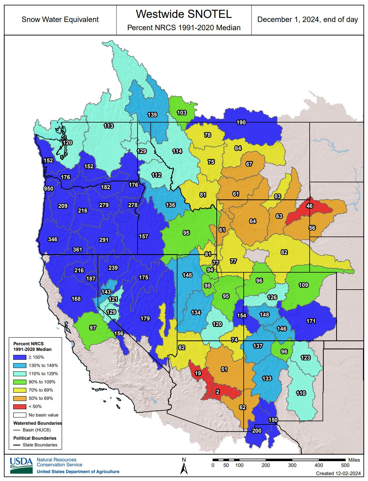
And here is a way to think about snow distribution on a larger scale. The map below shows Snow Water Equivalent (SWE) percent of median based on remote data from SNOTEL sites across the west. Can you see a pattern in this distribution?
OK, that is enough to chew on for today. Think about distribution as you are moving through the backcountry and as you are moving through the world. Of course, it is hard to know the distribution of something without making and recording quality observations… Observations are a massive topic and will be the focus of the next Framework section. Stay tuned and enjoy a big dose of sunshine this week, the flakes will be flying again soon.
-Ben VandenBos
CURRENT LOCATION: Tom Miner Basin, MT