
JANUARY 29, 2026
Snowfall returns, temperatures plummet, avalanche danger spikes and eases, drought surfaces develop, facet-lanches arrive, we extend some avalanche forecaster appreciation, and look into the future.

WEATHER AND AVALANCHES
A closed low moved onshore into Northern Mexico to end last week and bring us into the weekend. This spun large amounts of water into the Four Corners area. It collided with a cold air mass drawn down off the Canadian Shield, producing low-density snowfall on Saturday with generally calm winds. In many places, this was the first measurable precipitation in weeks. Unfortunately, wind speeds picked up significantly on Sunday as the system exited, easily transporting the fluffy powder that fell.
Danger spiked to high in small areas of Colorado and New Mexico on Saturday and Avalanche Warnings were issued. The CAIC issued Special Avalanche Bulletins (SAB) in many portions of the state. A widespread cycle of relatively small natural avalanches occurred during this period, in addition to a number of human-triggered slides.
The same atmospheric setup brought small amounts of snow to the mountains on the eastern margin of the ridge in Montana and Utah, which improved riding conditions significantly. This also resulted in bumps into MODERATE avalanche danger in places that had hung out at LOW during extended portions of the January Drought.
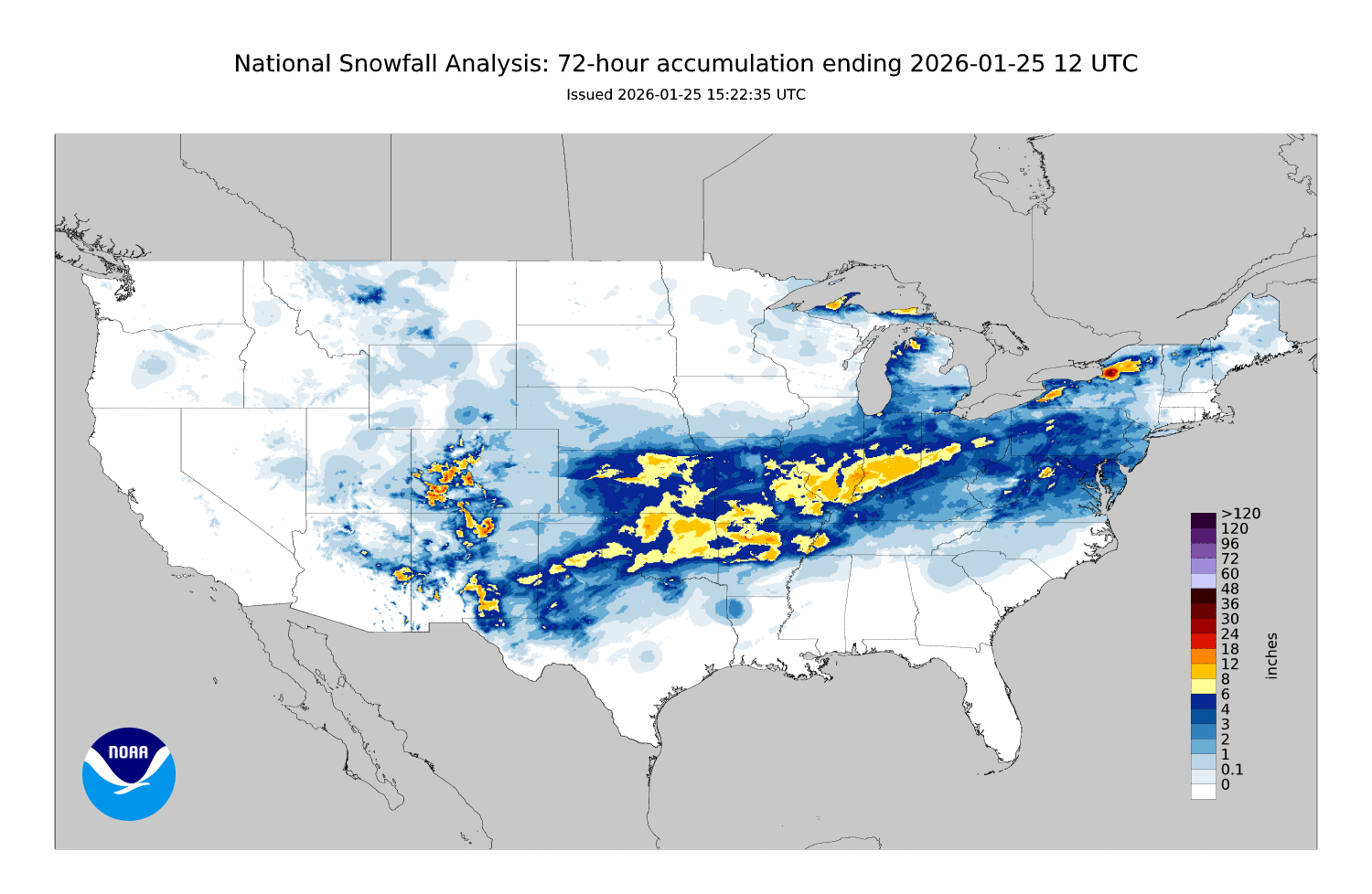
This storm continued north and east across the US, bringing a round of hazards to a broad swath of the country: feet of snow, cold rain, ice measured in inches, and a round of tornadoes. Snow accumulations in the southern tier ended up lower than forecast, as the warm center of the low strayed a bit further north than expected. The map below shows where snow fell during this 3-day period:
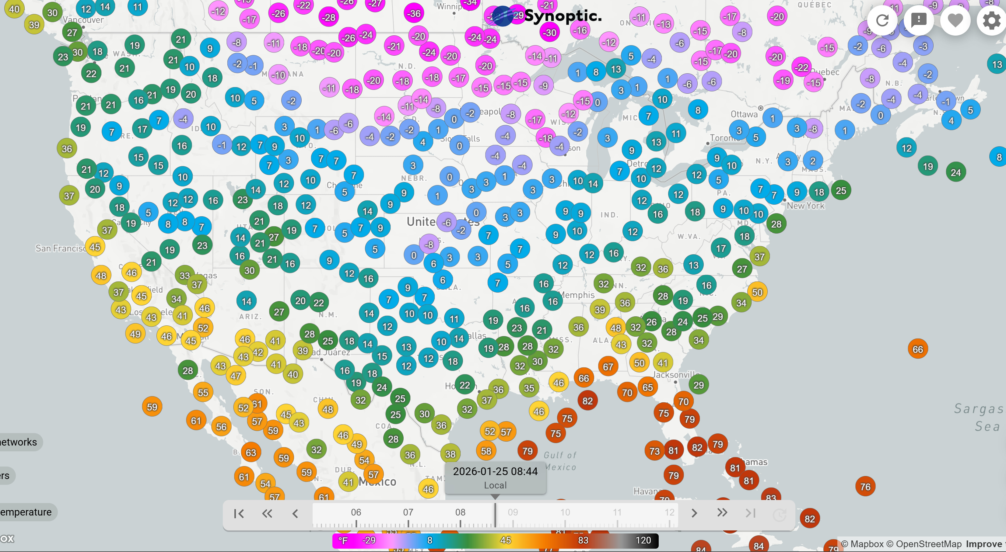
In addition to the wintery precipitation, this atmospheric setup allowed for frigid air from the Canadian Shield to move over a large portion of the country. The map below shows air temperatures (in degrees F) on Sunday morning (1/25). Brrr! Note the 110+ degree difference between warm areas of the country (southern Florida) and cold areas (Minnesota, North Dakota, eastern Montana).
Over the past few days, weak storms moving out of the Pacific ran into the forever ridge parked over the West, bringing a return of cloud cover to the droughted regions and a few helpings of snow to favored terrain. Most of the action has focused on the coast, from Northern California up through the Canadian border. Snow lines were initially low, but are climbing quickly as I write this. Unfortunately, precipitation is switching over to rain in many locations near the coast. Further inland, temperatures are expected to stay bit cooler and rain lines a bit lower.
AVALANCHE DANGER
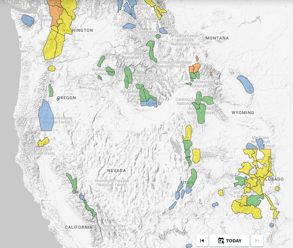
The map below shows avalanche danger across the Western US as of Thursday, 1/29. We’re still seeing large areas of LOW danger in the places that have been shorted on snow in recent weeks. There are a few areas of elevated danger to focus on. The storm that is currently delivering some much needed snow to the Pacific Northwest has bumped danger due to new snow problems up high and wet snow problems down low, where rain is falling. Portions of Montana have tallied a trickle of recent snow, with enough accumulating in favored portions of Southwest Montana to bump the danger to CONSIDERABLE. In Colorado, danger is on a downward trend following the storm this weekend. Unfortunatley, this storm fell on a weak, shallow snowpack and Persistent Slab problems top the list. I don’t know about you, but I’ll take a new snow problem over a lingering Persistent Slab problem any day of the week.
SURFACES
This week brought a welcome refresh of surface conditions to many locations. Snow totals were generally on the light side, but it didn’t take much to improve the riding. The new snow fell on a variety of drought surfaces that formed during the January hiatus in precipitation. Common themes are stout, rugged crusts on solar aspects, very weak, cohesionless facets on shady slopes, and variable breaker crusts in the space in between.
Reading observations from across the country is quite enjoyable. It’s fun to see the different ways people describe conditions. The best observations provide a window into a day in the mountains, offering the reader a good sense for what they might find when they go out in the backcountry. Here’s a great description from a public observation submitted to the Flathead Avalanche Center by Grant Hughes:
Crusts were the name of the game. Some trees had melted and frozen around the trees creating 4-6” ice crusts that acted like Mario Kart speed boosts when you hit them. Don’t end up with your tips under them.
I don’t think I’ve heard the icy, refrozen patches under trees described this way, but I have experienced these conditions many times… You are skiing down, weight in the middle of the skis, balanced, and then you hit one of these patches and your skis take off out from under you, rocketing you down the slope in the backseat... Yeehaw! Great description, Grant.
TODAY’S SURFACE, TOMORROW’S (or next month’s?) WEAK LAYER
As we sit through an extended drought, finding quality riding conditions becomes more difficult. And while our focus may be on locating good turns, extended droughts are great opportunities to watch the snow as it does its thing. Snow is always changing, sometimes gradually and sometimes rapidly.
If you want to spend a little time diving into energy balance at the snow surface and weak layer formation, Bruce Jamieson, with the help from other avalanche professionals, has produced some excellent videos covering the topic. You can find all of Bruce’s videos at his YouTube channel and on his website. Go check them out, there is something for everybody.
Across large portions of the West, conditions in January have been favorable for generating weak layers. The middle of January brought an extended period of surface hoar formation in many places, and the colder temperatures over the past week to 10 days have been aggressively faceting the upper snowpack. As this happens, snow can quickly go from strong and internally bonded to weak and cohesionless. When facets developing in the upper snowpack become significantly advanced, they become capable of producing dry loose avalanches. As this happens, these types of slides initially need a trigger (you), but once the process is sufficiently advanced, the incredibly weak facets just start falling off the mountain.
Many forecasts and observations in the West currently describe this problem. In Montana, a seasoned ski guide and friend triggered a long-running facet sluff that quickly picked up speed and force as it rocketed downslope:
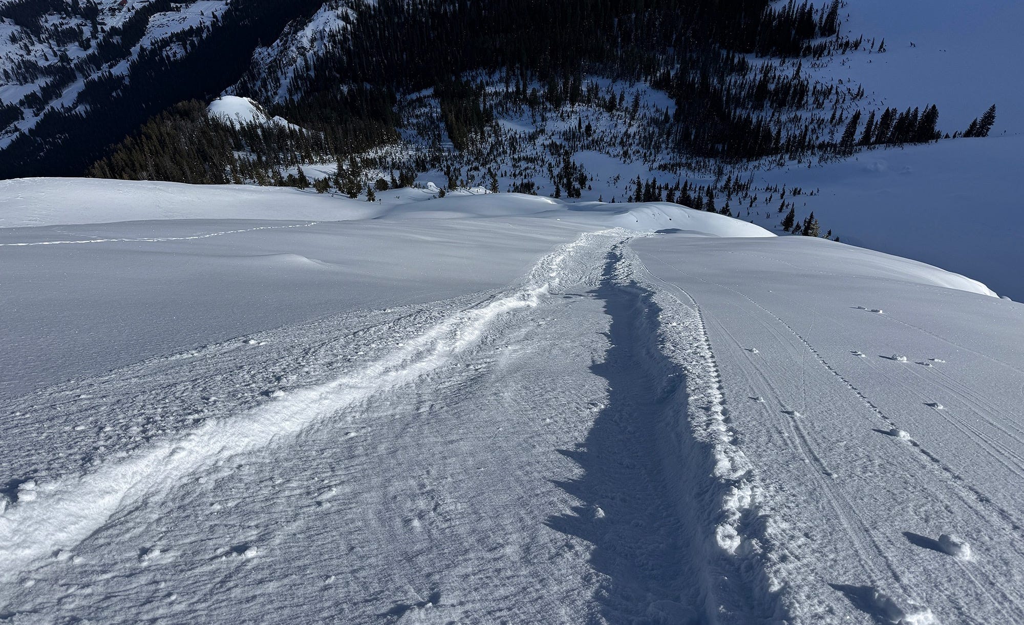
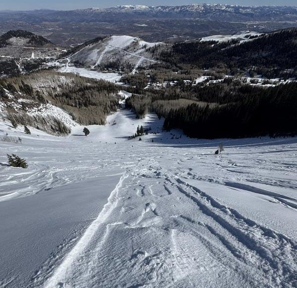
In Utah, several observations point to this same problem and it is mentioned in their forecasts. Craig Gordon, a long-time forecaster at the UAC, filmed a great video of one of these slides in action that you can find here. Go watch it, it’s wild. Mark White, a long-time observer for the UAC, reported triggering similar slides this week. In his observation, available here, he writes that “it was almost impossible to get on the slope without sluffing it out.” You can see these slides in the two photos below, which also do a great job of painting a picture of the meager winter that Utah is experiencing.
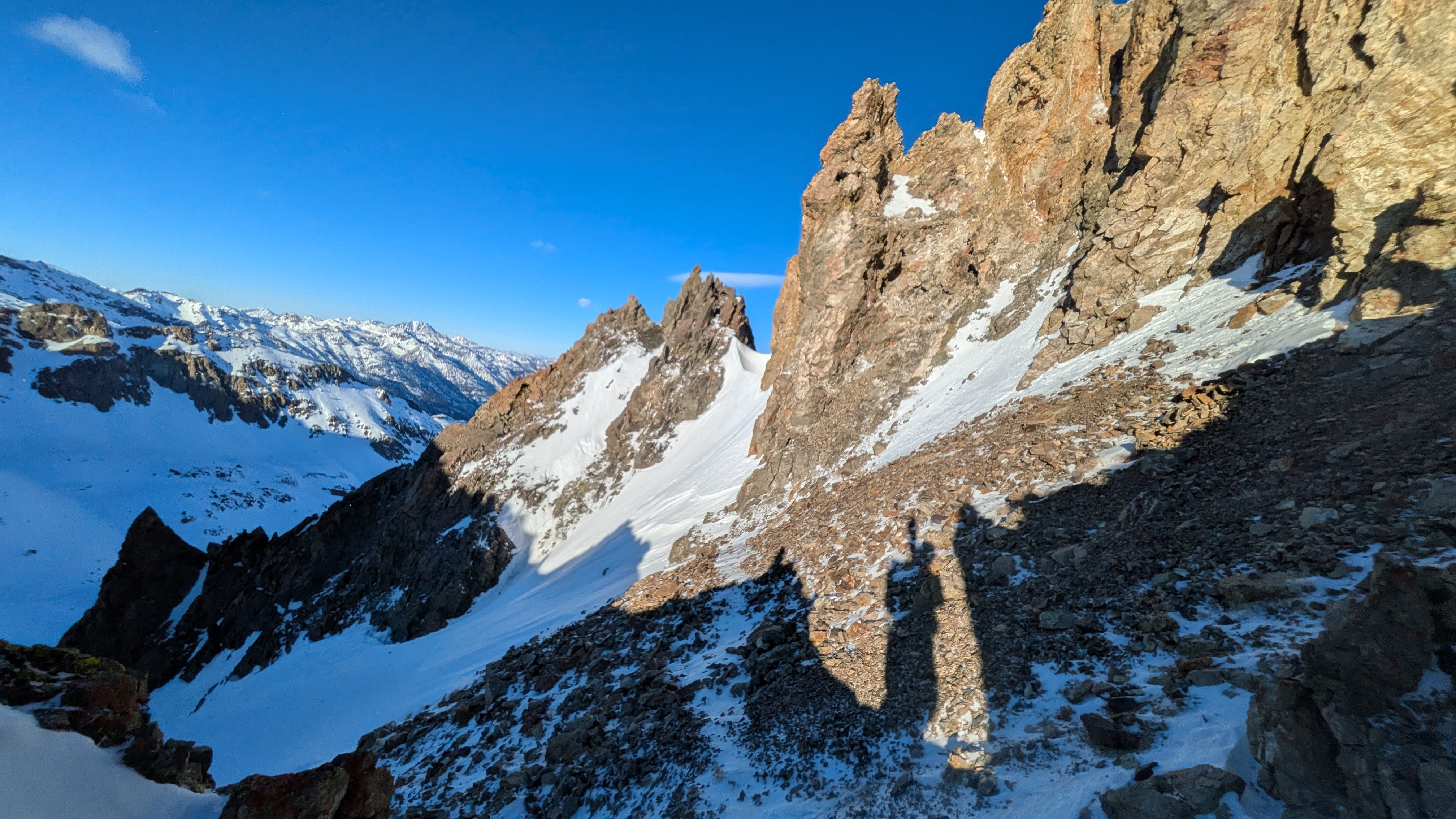
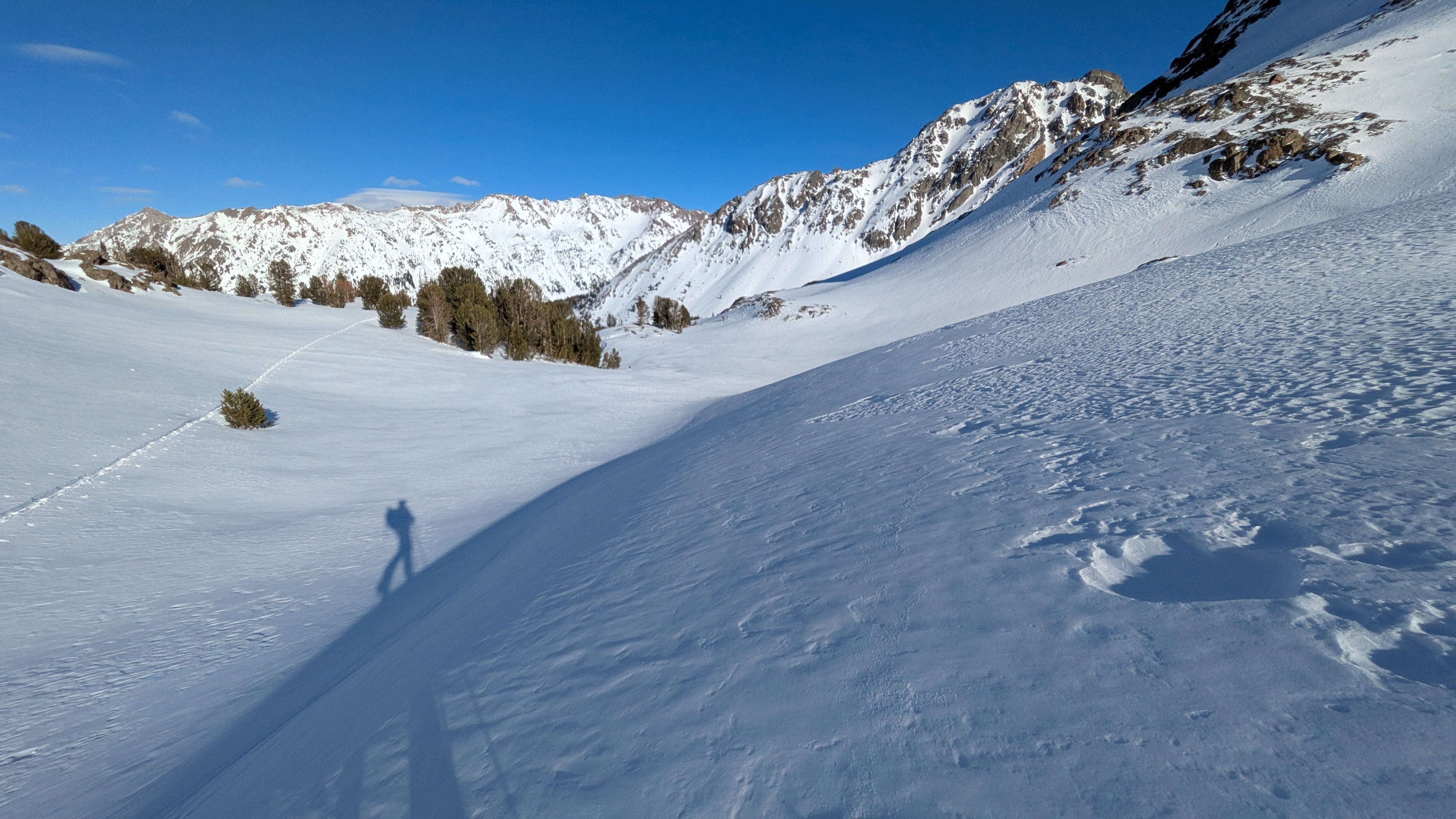
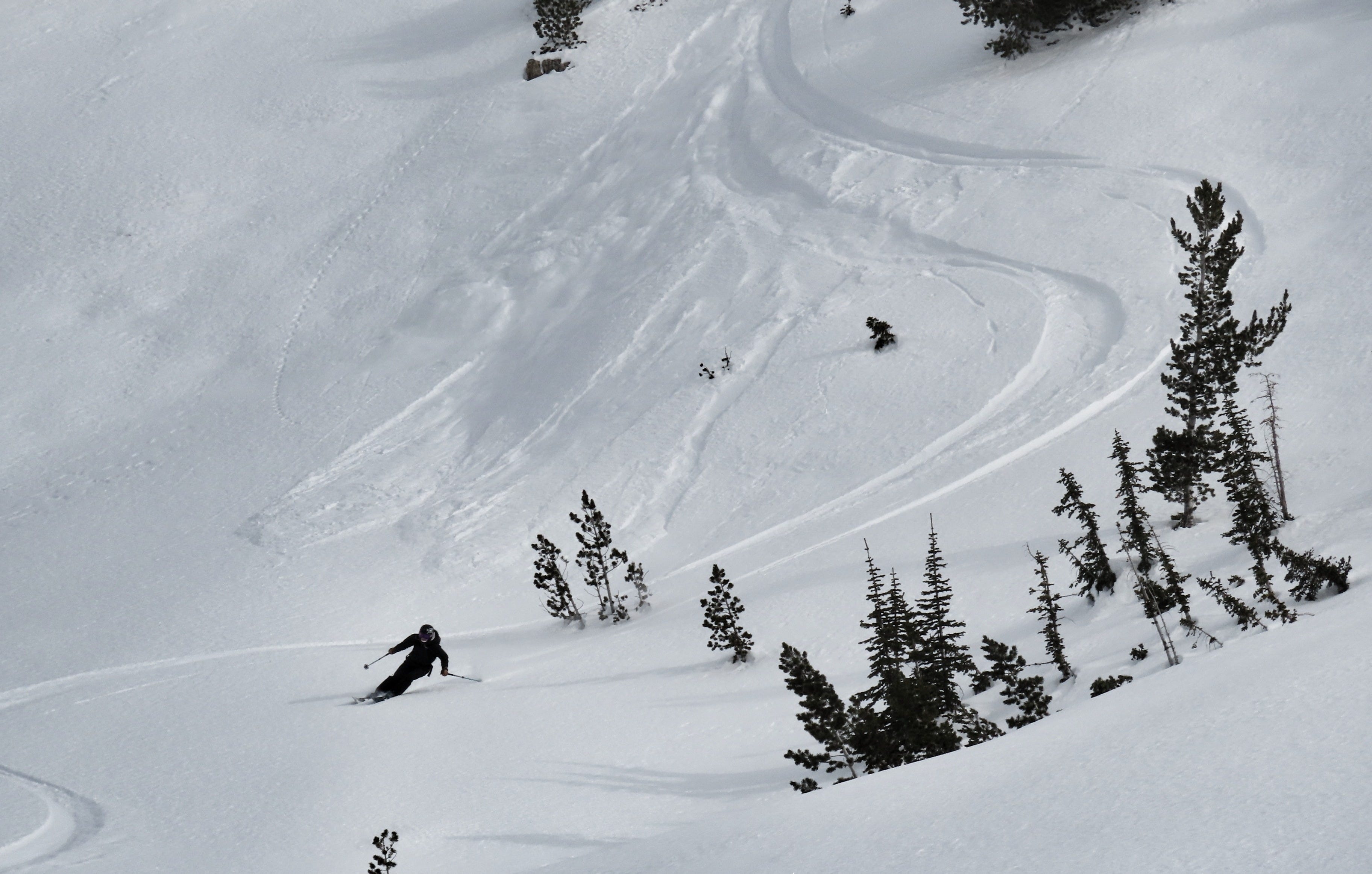
And here in the high peaks of Central Idaho, we are experiencing the same problem. It requires a steep slope, but once you get these moving, they want to keep rolling down the hill. The photo below shows a few small triggered sluffs at the bottom of a slope; these became quite a bit larger in big terrain.
If you are playing in big, steep terrain and finding a deep pile of faceted snow, triggering one of these slides can be easy and the slides can become dangerously large. Facet sluffs tend to behave a bit differently than more normal dry loose avalanches because the facets themselves are actually quite dense. And, instead of having long arms like fresh snowflakes do, they are compact and they almost seem to roll and bounce down the slope. Watch Craig’s video linked above for a better sense of this.
In most places, these facet-lanches aren’t a problem in and of themselves, but they are a clear indication that we will have quite an ugly persistent weak layer in the snowpack once they are buried under a sufficiently dense slab. When it comes to weak layers at the snow surface, a lot can change between when we observe them and when they are finally buried. However, it becomes very difficult to round a thick pile of facets. Generally, once facet sluffs are on the menu, the point-of-no-return has been crossed.
FORECASTER APPRECIATION CORNER
It has been a grim snow year in the West! No two ways about it. I don’t like to dwell on the lean side of things, but the intention of these posts is to describe the world as it is. Take a look at SWE as a percent of the median in Colorado as of yesterday:
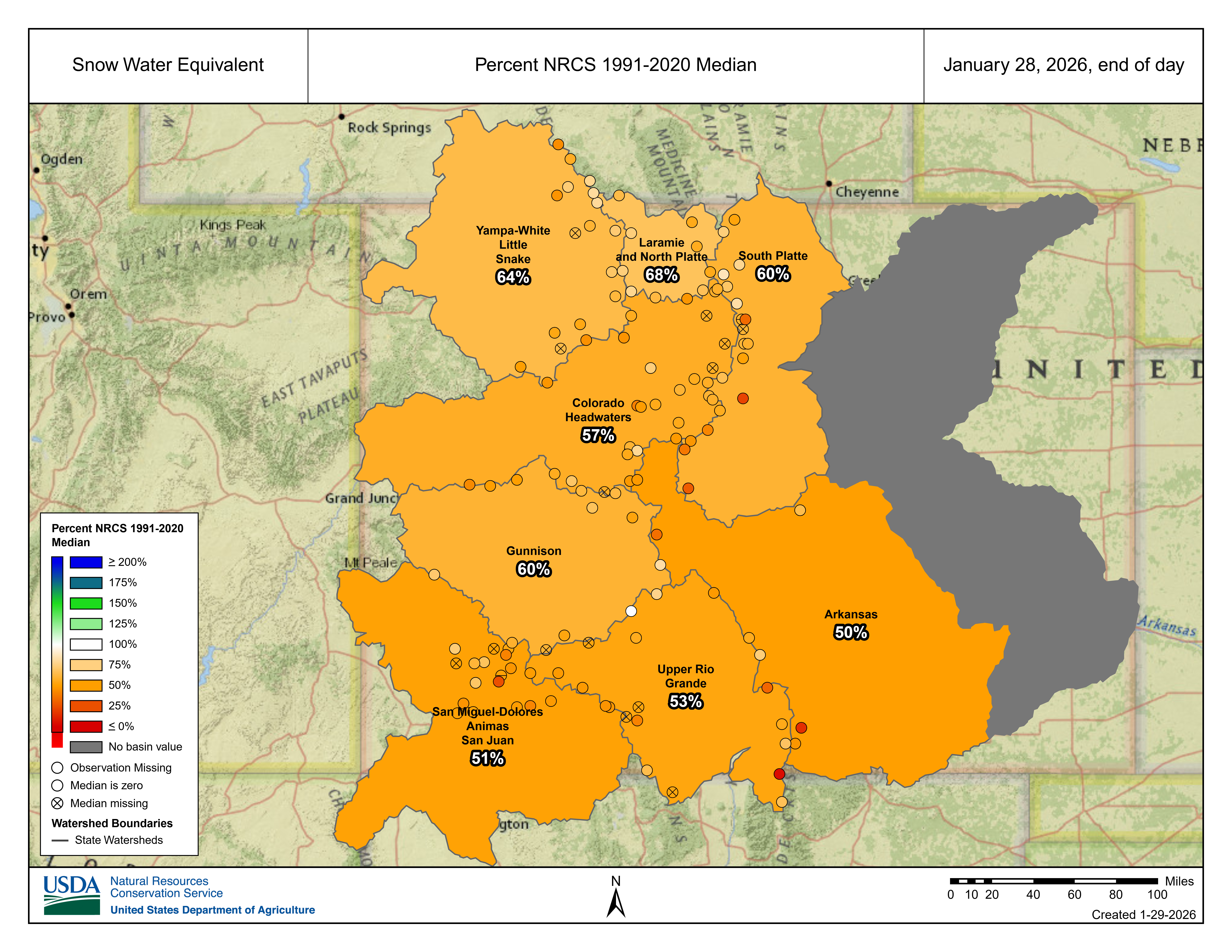
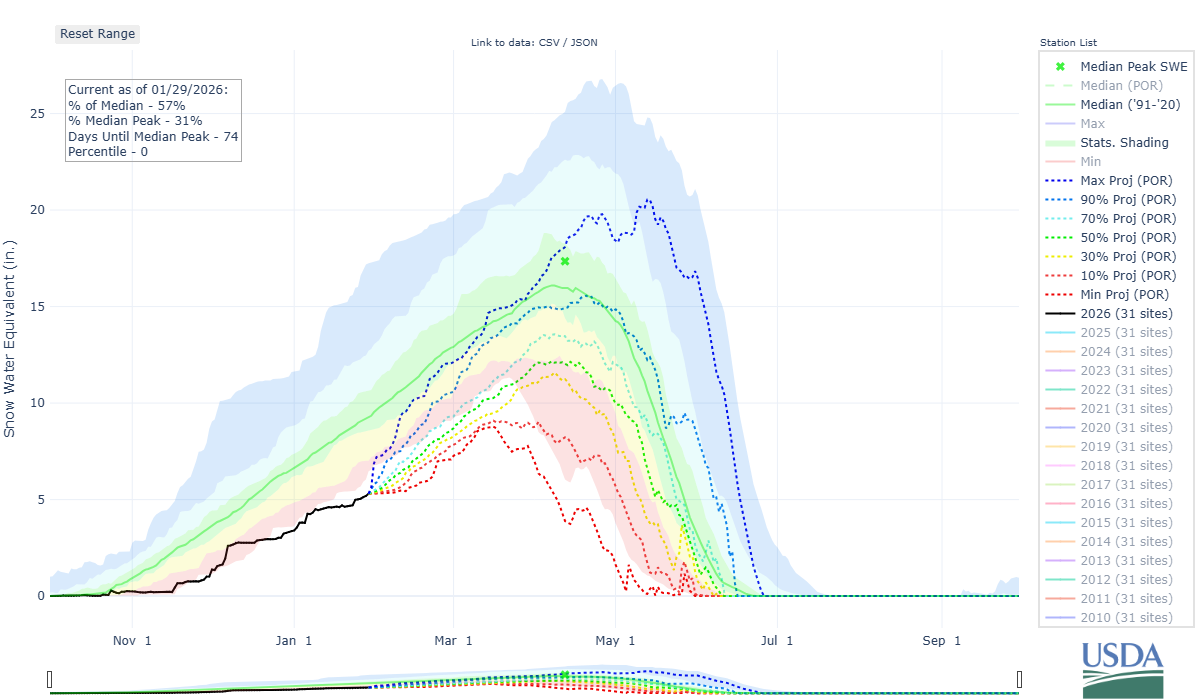
Diving a bit deeper into the Colorado Headwaters, we see SWE at 57% of the median as we move into February. Oof. The black line on the chart below shows SWE for this season - you’ll note that this line has been below the colored shading since around Christmas, indicating that a new low-water mark is being set. The dotted lines that extend from the black line indicate possible scenarios for the remainder of the season, based on how previous seasons have unfolded. At this point, it would take a historic late-winter/early-spring season to even get back to median peak SWE by mid-April.
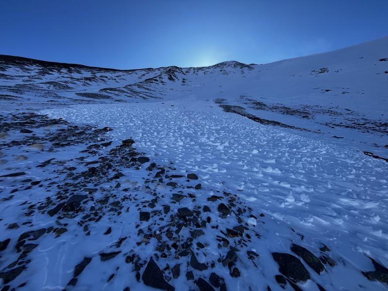
Graphs and numbers aren’t for everybody, but if you read through observations across the nation, you get a pretty good sense of how desperate this winter has felt. The slide pictured below is from the La Sal Mountains, on the eastern border of Utah, where similar conditions to those in Colorado can be found. It does a good job of painting the scene:
In the Pacific Northwest, the amount of precipitation hasn’t been a major issue, but the temperatures and precipitation type sure have been. Most of the season’s storms have been quite warm, and precipitation has fallen as rain repeatedly, all the way to the summits of the peaks. Access is incredibly challenging; many roads and trails were damaged or destroyed by torrential atmospheric rivers, acres of downed trees cover typical trails thanks to the mid-December wind event, creeks are open and flowing, and even if you make it up high, the surface conditions have been…unfavorable.
The two photos below, from NWAC forecaster Irene Henninger, do a pretty good job of painting the scene. The first shows Buck Mountain in the East Central Zone, with a summit at 8,400’. From Irene: “Note the glide cracks, runnels, glide avalanches and wet loose avalanches, all seen in this image.” Wow, those mid-winter runnels are remarkable.

This second photo, taken by Irene a few days later in the West Central Zone, shows the snowpack on a N aspect at 4,800’. Note the two-foot-thick, knife-hard melt-freeze crust making up the upper snowpack. And the memo that “softer snow starts about 70cm down” with a descriptive emoji.

There are currently very few locations across the West with easy access and quality skiing and riding. Forecasters are putting in long days, starting in the dirt, struggling to keep machines cool, scratching at refrozen rain crusts with ski crampons, dropping through thin, entirely faceted snowpacks, and bouncing off the rocks and stumps below. I want to offer a heartfelt thank you to all of these good people doing this work. It’s not easy on the brain, heart, or body, but it is important work, and we are all lucky to have them. Take the time to thank these guys and gals when you see them out in the mountains.
STUDY PLOTS
One of my favorite things about snow is that it is always changing. No two days are the same, even when it hasn’t snowed in 3 weeks. As backcountry travelers (and our own personal avalanche forecasters), part of our job is to keep tabs on evolving conditions. We can do this by reading observations, talking with friends, and paying close attention to avalanche forecasts.
Another great way to watch conditions change is to establish and monitor study plots. This doesn’t necessarily have to be a highly scientific endeavor. Most skiers and riders are already returning to similar areas multiple times throughout the season. Taking the time to note and describe conditions, and then comparing these observations to your previous visit, is a great way to watch the snow change.
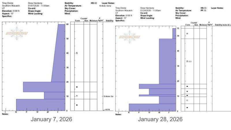
You can take this one step further by choosing a location to dig a snowpit, and then digging in close proximity on your next visit to this location. When winter is in full swing and the skies are dumping flakes, it can be hard to even find your old pit. On lean years, the pit you dug last week might still look pretty crisp. Take a look at this photo below from Drew Hardesty, friend and long-time forecaster with the UAC. These two snowpits were dug 3 weeks apart! Wow…yikes.
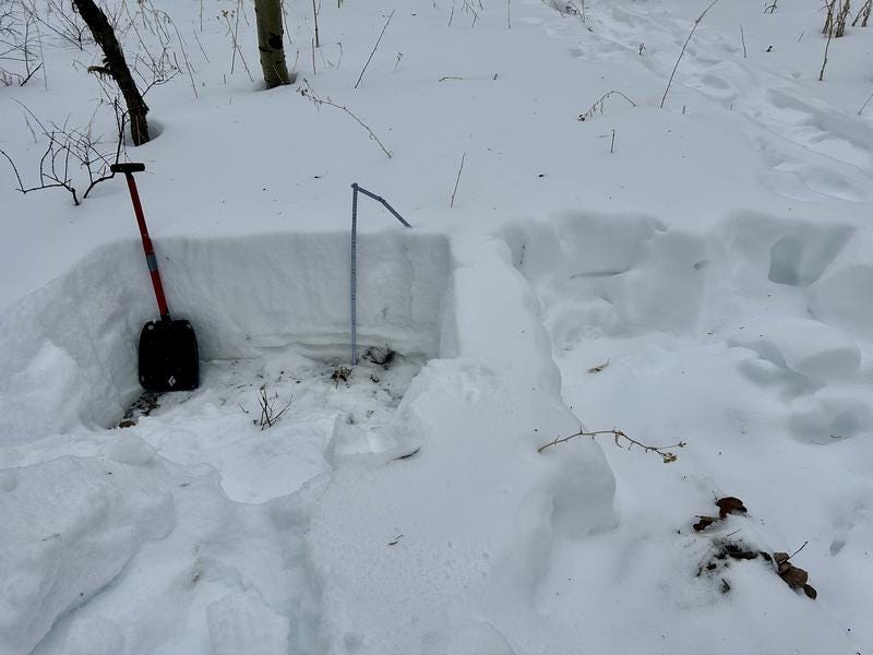
And here are Drew’s two snow profiles from these pits:
Dallas Glass, Avalanche Forecaster and Deputy Director of the Northwest Avalanche Center, made a similar point about the benefits of returning to known locations to watch things change in his observation from Paradise at the base of Mt. Rainier earlier this week. Go give it a read. And, since we are talking about Dallas, I wanted to share a quote from his observation near Snoqualimie Pass today. I think most of us in the West share Dallas’ excitement about the new snow.
SNOW!!!! After this long dry spell, it sure was nice to see snow in the trees! We found about 4 inches of snow near the trailhead and about 8 inches above 4500ft. It's not exactly blower powder, but we'll take the heavy wet snow.
A dry winter can be tough to live through, but it is also a good reminder of all that the snowy mountains provide. There’s a magic to something as simple as just seeing snow in the trees. We forget that when are buried in our riches and the snow just won’t stop. I couldn’t help but wear a big smile when I read this observation. Thanks, Dallas.
LOOKING AHEAD
As the old adage says, if you’re looking for fresh snow, head to North Carolina. Wait…what? Yep, aside from the tops of the high volcanoes along the West Coast, the coast of North Carolina looks like it will be the big winner over the next few days. Terrain around the Great Lakes and in the Northeast could also do ok, but there is so much ice on the lakes that lake effect snowfall is becoming less productive and less predictable. Northwest Montana, far northern Idaho, and the Washington Cascades will all pick up some snow, but rain lines appear to again be unfortunately high.
And, following these storms through the weekend, we move back into a period of ridging across the West. Yep, the forever ridge rebuilds. But, take heart, my friends, there does seem to be a bit of light at the end of this long tunnel! Weather models are coming into some agreement on a shift in patterns for the West during the second week of February. It is too far out to have much confidence, but it is worth watching.
Envision a hypothetical future with me: the drought breaks, snowfall returns in earnest, skies clear, and we are skiing powder in the sun before Valentine’s Day. Cautiously skiing powder on low-angle slopes, well aware of the long-developing weak snow below.
Peering even further into the future proves murky at this time. But….let’s give it a shot. I like using the Climate Forecast System Version 2 model when I’m really grasping at straws. Following storms in the West from (very roughly) February 8-12, the ridge attempts to rebuild. But, the axis of the ridge appears to shift further towards the coast, with large areas of northwesterly flow spilling down its eastern limb. Portions of the Intermountain West can do quite well in this pattern, from Utah to Montana to Wyoming to Idaho.
Let’s not count unhatched chickens, but it never hurts to carry some hope out into a dark world. Time will tell, and we will all be out there watching.
Thank you, as always, for your time and for your attention. I’ll see you back here next week.
-Ben VandenBos
The study plot comparison three weeks apart is striking. I've been tracking surface changes this season too and the facet progression has been faster than I expected. That point about facet sluffs behaving diferently because of density is something I hadn't considered before, makes sense why they gain so much momentum on steep terrain.