
PATTERN AND MINDSET SHIFT
A dry-ish January, an extended drought ends, and a very weak surface is rapidly loaded. Plus a diversion into Avalanche Watches, Warnings, and Special Avalanche Bulletins and some thoughts on mindset.

Note: I ended up splitting this into two posts. This one about regional conditions, and a more detailed local snowpack inventory for central Idaho that I will likely publish tomorrow morning.
January has been a dry month for much of the Intermountain West. Areas hit the hardest by the recent drought include California, Nevada, south and central Idaho, much of Utah, Washington, Oregon, western Colorado, Arizona, and New Mexico. Storms riding the backside of the ridge of high pressure parked on the West Coast have been periodically delivering snow to Montana, Wyoming, and central and southern Colorado during the second half of January. And Arizona and New Mexico finally broke a nearly 3-month-long drought this week as a big storm lumbered across the Southwest! Wow, 3 months. And you thought it was dry where you lived…
Find below a GIF showing where snow has been falling since mid-January. Watch this a few times, here are a few things of interest to look for:
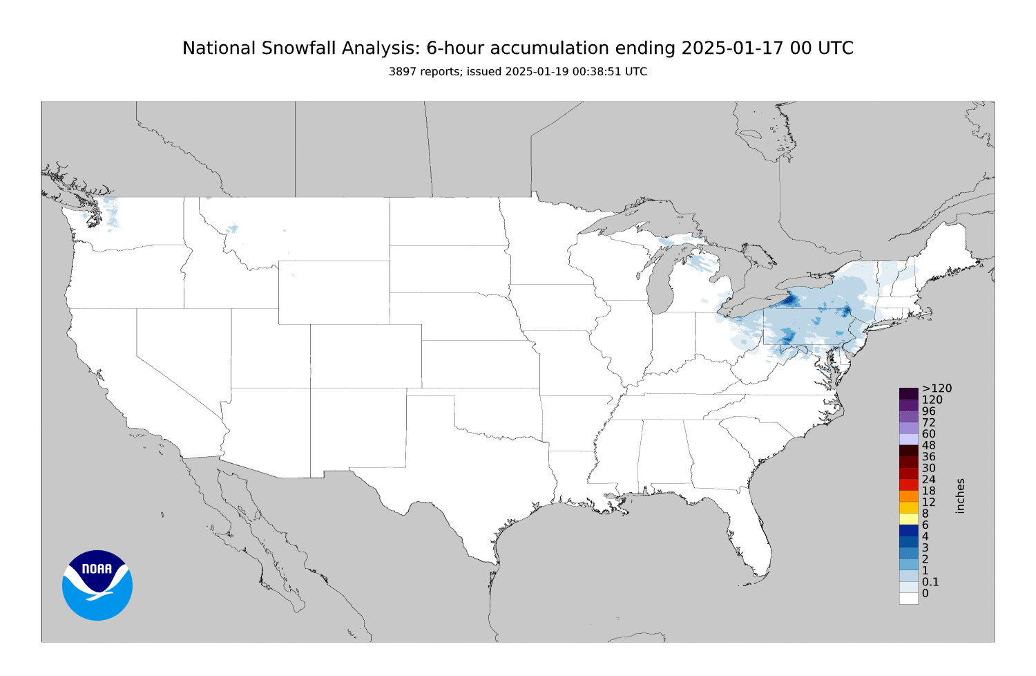
There has been as much or more snowfall to the east of the Mississippi than to the west.
On January 22 and 23, the collision of an arctic air mass and moisture from the Gulf of Mexico resulted in record cold and snowy conditions along the Gulf Coast.
The 3-month drought in Arizona and New Mexico ended!
Snowfall returns to the Pacific NW at the end of the loop (this morning).
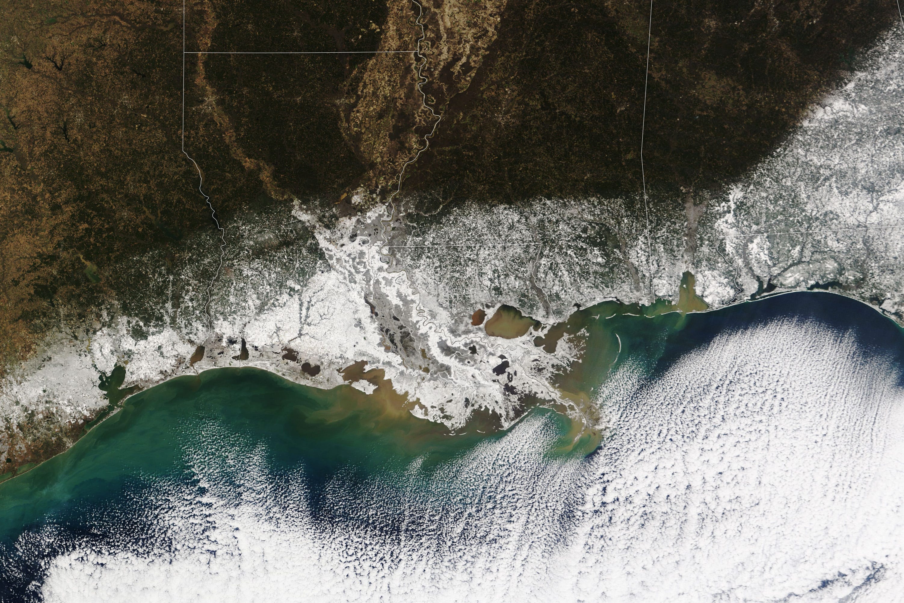
Here is a satellite’s view of that snowfall along the Gulf Coast from NASA’s TERRA:
NATIONAL AVALANCHE CONDITIONS
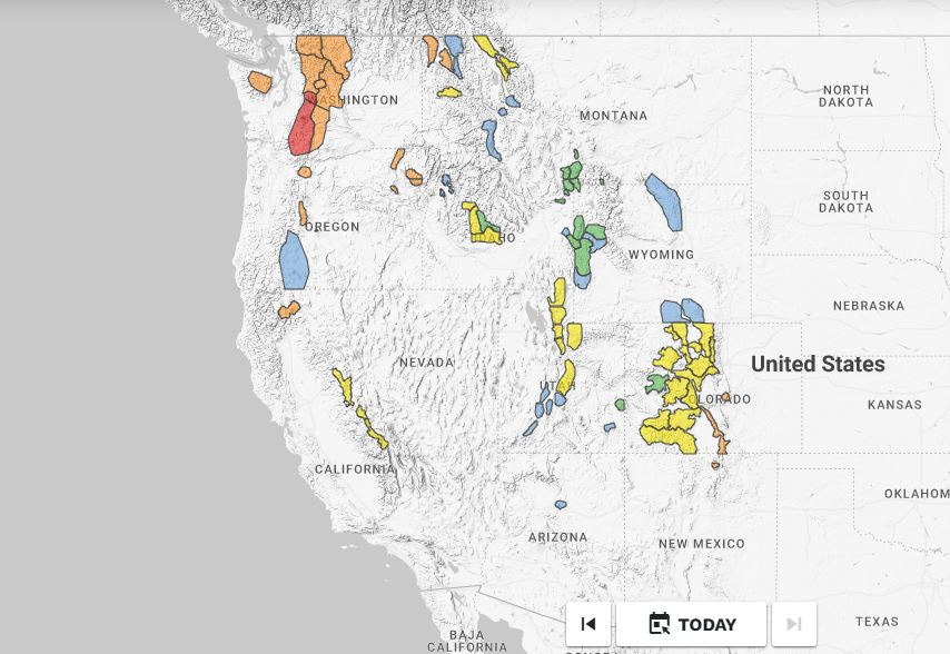
Below you will find two maps from Avalanche.org. The first shows the Avalanche Danger yesterday (1/30) and the second shows the Avalanche Danger as of this morning (1/31). It has mostly been a sea of low and moderate danger recently, but that is changing quickly. Here’s a look at yesterday:
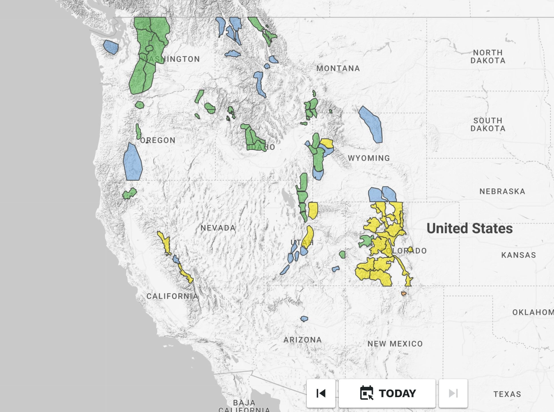
Look closely and you’ll find a small blob of considerable danger in the forecast area for the Taos Avalanche Center in northern New Mexico, thanks to the drought-breaking storm that just impacted the southwestern US (different from the storm that brought snow to the Gulf last week).
The Pacific Northwest saw a brief jump to moderate danger for wet snow concerns earlier this week, but cooling temperatures, winds, and a lack of natural activity brought the danger back to low. The Sawtooth Avalanche Center in Idaho saw a similar jump to moderate danger on Wednesday, breaking a rare, extended streak of mid-winter low danger. The same storm that is bringing snow to Arizona and New Mexico dropped snow on California earlier in the week, raising concerns for fresh wind slabs in areas favored by snowfall and then small wet loose avalanches as this new snow was shed in the sun.
Notably, despite the drought and lack of loading, many avalanche centers continue to describe a persistent slab problem in their forecasts. The Late-Fall Drought Layer (LFDL, buried in early/mid December) remains the primary persistent slab concern in areas that have received less snowfall this season (central Idaho, Utah, Wyoming, and thinner snowpack areas in Colorado). Portions of Colorado that have received more snow during the month of January are also dealing with persistent slab issues from weak layers further up in the snowpack. Follow this link to see a video of a remotely triggered avalanche that failed on a recently buried crust+facet combo near Loveland Pass.
And here is a look at the national danger map for today, January 31. Another Atmospheric River has drawn and bead on the West Coast and snow is returning. Scroll back up to yesterday’s map to pick out some of the differences, they aren’t hard to find.
WATCHES, WARNINGS, and SPECIAL AVALANCHE BULLETINS
This can all be a bit confusing, but I think it’s worth a quick diversion:
The Avalanche Forecasting system in the United States is decentralized. While there is a National Avalanche Center (NAC) that offers guidance, each local Avalanche Center follows this guidance how they best see fit. In recent years, many US Avalanche Centers have begun to use the Avalanche Forecasting Platform provided by the NAC. Because of this, most of the US Avalanche Center web pages and forecasting products now look pretty similar. There are still a few major outliers within the US who are not using this platform, including the Utah Avalanche Center and the Gallatin National Forest Avalanche Center.
If you travel abroad you will see avalanche forecasts that look quite a bit different. Head over to Avalanche Canada’s site for a look at a more centralized Avalanche Forecast. Still curious? Navigate your way over to the European Avalanche Warning Services (EAWS) page to see what is going on across the pond. In Europe, each country has their own Avalanche Center. Collectively they are known as the EAWS. (The web address for the EAWS page is Avalanches.org; your browser might not like how close this is to the US page at Avalanche.org).
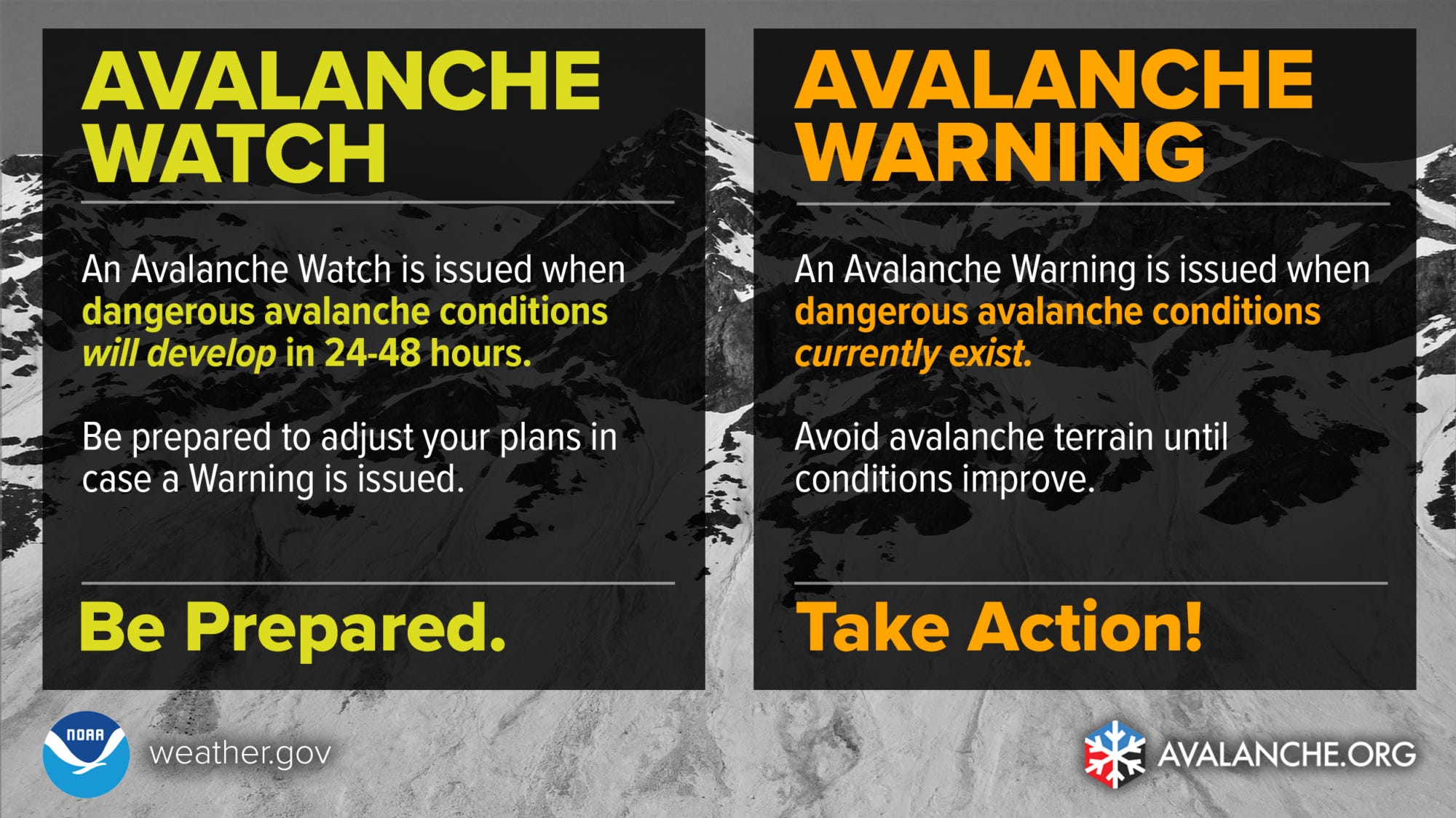
One area where there is a lot of discrepancy between different US Avalanche Centers is in the use of Avalanche Watches, Warnings, and Special Avalanche Bulletins (SABs). Watches, Warnings, and SABs are National Weather Service (NWS) Products that are issued at the request of local Avalanche Centers. The NWS issues Watches and Warnings for all sorts of hazards. You’ve certainly seen Winter Storm Watches and Warnings, High Wind Watches and Warnings, Severe Thunderstorm Watches and Warnings, etc.
Watches are issued when dangerous/impactful conditions are expected to develop in the near future, and Warnings are issued when dangerous/impactful conditions currently exist. Take a look at the infographic below:
Digging in a bit more, we find this definition in the Avalanche.org avalanche encyclopedia:
The intent of an Avalanche Warning is to save lives by alerting the public when large avalanches are very likely or certain in many areas and when unusually dangerous avalanche conditions exist. For example, Avalanche Warnings are issued when a significant avalanche cycle is expected or if the danger is expected to reach High or Extreme.
Ok, that sounds simple enough. Watch = things are going to get dangerous, Warning = things are dangerous right now. Most US Avalanche Centers issue Avalanche Warnings, though their specific criteria for issuing them varies from Center to Center. Avalanche Watches are used less regularly. Some Centers use them and some don’t.
RIGHT NOW:
By my count, there are 4 Avalanche Centers in the US that have active Avalanche Watches out as of 1/31. These Centers are anticipating that conditions will get very dangerous soon. The affected mountain ranges described below come directly from the text of the published Avalanche Watches:
The Utah Avalanche Center has issued an Avalanche Watch for the mountains of Northern Utah and Southeast Idaho
The Flathead Avalanche Center has issued an Avalanche Watch for Glacier National Park and the Whitefish, Swan, and Flathead Ranges
The Idaho Panhandle Avalanche Center has issued an Avalanche Watch for the Selkirk, West and East Cabinet, Purcell, and Bitterroot Mountains
The Central Sierra Avalanche Center has issued an Avalanche Watch for the Central Sierra Nevada Mountains between Yuba Pass and Ebbetts Pass, including the greater Lake Tahoe area.
I expect to see many/most of these Watches get upgraded to Warnings within the next 24 hours. I also expect that Avalanche Warnings may be issued by Centers that have not issued Avalanche Watches. Like I said, this can all be a little bit confusing. But don’t worry, there’s more!
Special Avalance Bulletins are a bit more complex, and their use is not widespread across US Avalanche Centers. The Northwest Avalanche Center has issued a Special Avalanche Bulletin for the Washington Cascades from the Candian Border to the Columbia River, Mt Hood, and the Olympic Mountains. Their SAB states: “A significant winter storm, a variable and weak snowpack, and a busy weekend could combine for uniquely dangerous avalanche conditions. Avalanche may trigger easily and could break widely.”
According to the Avalanche.org Avalanche Encyclopedia:
Special Avalanche Bulletins (SAB’s) are impact-based products. These are issued when significant public use is expected and dangerous avalanche conditions exist, but the avalanche conditions do not meet the level necessary to issue an Avalanche Warning. Special Avalanche Bulletins are often issued when especially challenging and dangerous conditions overlap with a busy weekend or holiday
From personal observations, the Colorado Avalanche Information Center (CAIC) is the most frequent user of SABs. They have issued them a few times already this season.
RECENT AVALANCHES
Thanks to the drought that is drawing to a close, the past two weeks have been relatively quiet, avalanche-wise. Below you can find links to a few notable observations of human triggered avalanches that occurred this week (click the date/location for the link).
COLORADO:
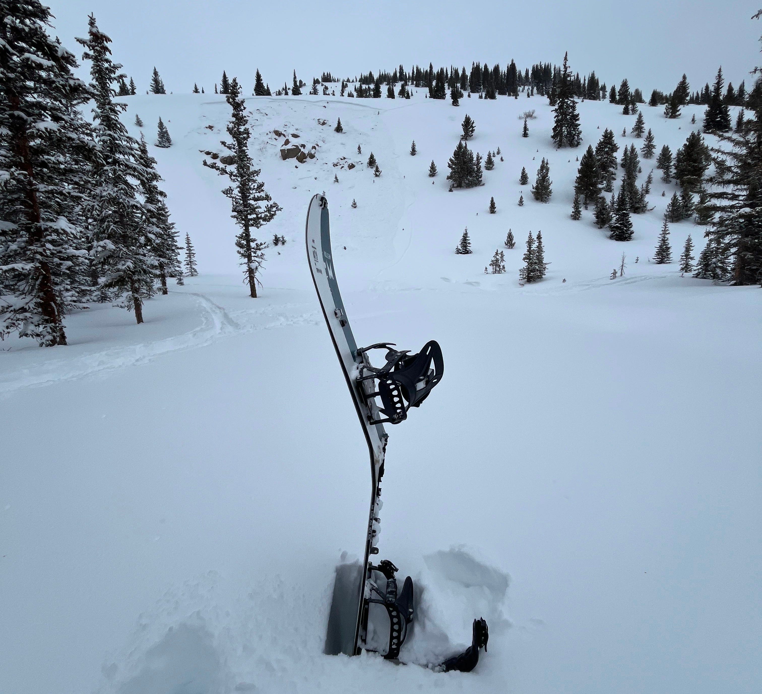
January 25, 2025 - Berthoud Pass - A snowboarder was caught and carried in a hard slab avalanche that they triggered. The slide broke about 30 feet above the rider on a SE aspect at 11,000’. The rider was uninjured but was pushed into a tree with enough force to break their snowboard (photo below).
January 27, 2025 - Alta Lakes - Skier triggered wind slab in a steep couloir on a N aspect at 11,900’. This was a small, thin wind slab avalanche. The reporting party captured an interesting video that you can watch below:
UTAH
January 26, 2025 - American Fork - Skier triggered hard slab on E aspect at 9,400’. Utah Avalanche Center forecasters went to investigate this avalanche two days later, you can read their observations here. Note: if you are trying to learn more about snow and avalanches, there are few resources better than reading observations from seasoned avalanche forecasters. Do it!
January 26, 2025 - Big Cottonwood Canyon - Skier triggered hard slab on N aspect at 9,400’. This is an interesting ob from a group of skiers that watched a separate trigger a slide. It’s worth a read and brings up some interesting points about traveling through the backcountry with other groups present.
LOOKING FORWARD - WHERE IS YOUR BRAIN AT?
The extended January drought created “great” conditions for weak layer generation at the snow surface, even in areas that don’t typically deal with Persistent Weak Layer problems. This snow surface is being buried as I write this, and Avalanche Forecasters across the West have their hackles up. And for good reason.
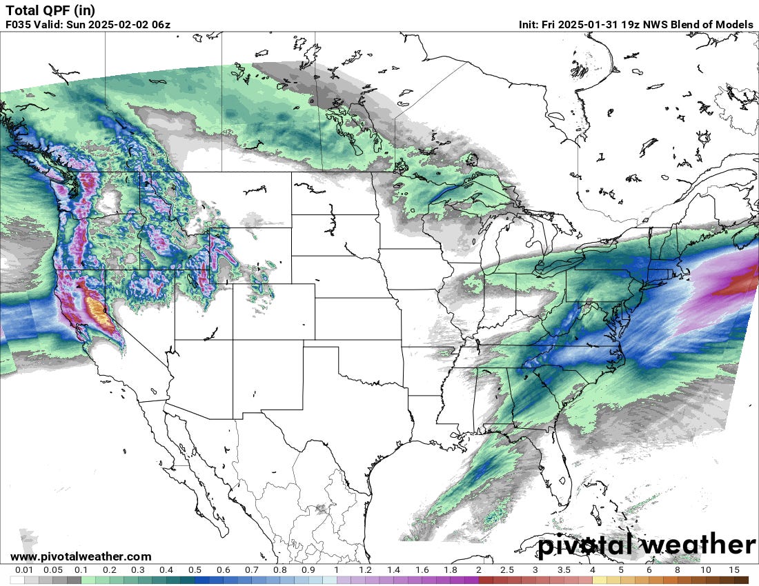
Here’s a look at how much SWE is forecast to fall by midnight on Saturday. In higher terrain this will fall as all snow, but significant rain is anticipated along the coast and at lower elevations. The purple colors indicate more than 1” of SWE, and the red color indicates more than 2” of SWE. Looking at north and central California you will see yellow (more than 4” of SWE) and brown (more than 6” of SWE). Across the Western US this snow will be falling on the January Drought Layer (JDL):
A long period without snowfall, widespread weak layers and atypical snowpack conditions, hordes of powder-hungry skiers and riders, and a multi-day atmospheric river are a “perfect” recipe for avalanche accidents. This is it, this is when things go sideways. This is when our friends don’t come home.
I’m not the fun police, and neither are the Forecasters at your local Avalanche Center. I want you to find excellent skiing and riding out there and to get so much snow in your face that you can’t wipe the smile off. But even more than that I want you to come home to your loved ones and tell them about it. Tonight and tomorrow night and the next night too.
Go into the backcountry expecting anomalous conditions and avalanches, and behave accordingly. Snap yourself out of the low danger doldrums and be prepared to enter a snow-covered world that can swallow you with indifference, and will, if you give it the chance. This is not just a reminder for you, dear reader. I’m writing this for myself as well. I have been playing in and around a lot of steep avalanche terrain and I recognize that it will take a significant amount of mental gymnastics to step back, particularly when faced with steep, open slopes of deep, untracked snow.
We can learn a lot about how snow and avalanches behave during times like this. Exercise your powers of observation and communicate with your partners and friends about what you are seeing out there. Read and submit observations to your local Avalanche Center. Let your smile melt the powder off your face, and most importantly, come home at night.
-Ben VandenBos
Too bad my trip to Taos was two weeks ago! Fortunately I am in Steamboat now where there is an avalanche watch with conditions expected to go into the red tomorrow - fortunate for a ski resort nearby and some fun low angle terrain!!! Loved the satellite photo of the snowy gulf! Cheers!!